SRR Long Run Library
These are some of our favorite long run routes. Choose your favorite and adapt as needed to fit your training! Here are the options:
Charles River loop: 2.5–20+ Miles
Boston Marathon Course: 11–20+ Miles
Minuteman Bikeway: Any distance
Mystic Lakes Loop: 5 miles per loop

Charles River loop: 2.5–20+ Miles
The Charles River paths are extremely popular among runners. There are limited road crossings, some bathrooms and water fountains, and very little elevation change. This is an excellent place to run during the summer months since there’s regular access to water or to do a workout without having to stop frequently at intersections.
A popular option is to meet at Artesani Park where there is a large parking lot, porta-potties, and water/bathrooms in the summer.
The route shown in the image is a 17.5 mile loop from Artesani Park, but you can create variations of almost any distance by just using different bridges. Running to the river from Davis Square via Harvard adds ~2.25 miles each way.
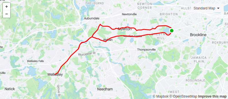
Boston Marathon Course: 11–20+ Miles
Long runs on the course are a staple of Boston Marathon training. Every weekend hundreds of runners run the carriage road along Comm Ave through the Newton Hills. You’ll see solo runners, training groups, and make-shift aid stations set up along the way. There’s nothing to get you in the marathon spirit like a long run on the Boston course!
A popular SRR option is to park on Beacon Street across from the Chestnut Hill Reservoir (2 hour non-resident parking) and run west on Beacon until intersecting with the Boston Marathon course at Washington St. From there you can turn right to run back on the marathon course through the Newton Hills for a nice 11 mile loop or you can add an out-and-back section along the course out to Wellesley or beyond to get as many miles as you’d like.
The route in the image shows an 18 mile route which includes an out-and-back which turns around in Wellesley Square.
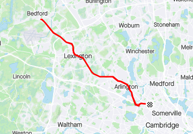
Minuteman Bikeway: Any distance
With minimal road crossings and a well-maintained surface the Minuteman Bikeway is a popular option for running and cycling for both exercise and commuters. You can connect to the Minuteman from Davis Square via the Somerville Community Path and the Cambridge Linear Park to Alewife and if 22+ out-and-back miles isn’t enough then you can continue onto the Narrow Gauge Rail Trail or the Reformatory Branch Trail at the Bedford end.
This is an excellent route for a workout. You can get a nice 2.5 mile warmup to Arlington Center and then start your workout on the slight uphill as the path heads out toward Lexington with relatively few road crossings. Turn around when you hit the distance you want and you can do the second half of your workout on the slight downhill for a nice negative split and a big confidence boost. This is a popular way for some SRR members to do marathon pace or tempo workouts. Get it!
The route in the image includes the full 22.6 miles out-and-back from Davis Square to the end of the Minuteman at Bedford Depot. Turn around whenever you’d like for shorter distances.

Mystic Lakes Loop: 5 miles per loop
If you’re looking for a medium distance route with few road crossings the Mystic Lakes loop may fit the bill. A single loop around the lakes is almost exactly 5 miles so you can easily add 5, 10, 15… miles by just running more loops (if you’re into that kind of thing. Running there and back from Davis puts this route at 9.7 miles for a single loop.
Expect nice scenery on this route, especially on the east side of the lakes. As an added bonus, there are portable toilets available at Shannon Beach in the summer, plus the option to cool off with a quick dip in the lake while you’re there.
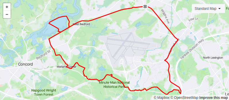
Bedford Depot Loop: 14.3 miles
Connecting the Reformatory Branch Trail to the Battle Road Trail results in lots of soft surface running with non-technical dirt/crushed gravel paths and about 10 miles of off-road running.
Park at Bedford Depot to start the loop in Depot Park or choose any of the lots along the Battle Road Trail for an alternative starting point. This route is definitely best when there’s no snow since the trails cannot be plowed or de-iced. There are bathrooms and water available during the warm weather months at multiple points along the Battle Road Trail.

Battle Road: 9.5 miles
Rolling hills on non-technical dirt and crushed gravel paths through the Minute Man National Historic Park make for a great medium distance run. SRR runs on this route typically start at the Wood Street parking lot and run the 9.5 mile out-and-back to Meriam’s Corner.
There is limited parking at the start location and a slightly larger lot on Old Mass Ave near Route 2A. Bathrooms and water are available during the warmer weather months at the visitor center, Bedford Lane near Hartwell Tavern, and Meriam’s Corner.

Fresh Pond: 5.5–20+ miles
If you’re headed to Fresh Pond you should expect runners, walkers, dogs, and maybe an Elizabeth Warren sighting. The paths around the pond make a great 2.3–2.5 mile loop depending on the exact route you take. It’s also only 1.5 miles from Davis Square, making for a shortest round trip with a single Fresh Pond loop a distance of around 5.5 miles.
A popular SRR option is to run from Davis to Fresh Pond to the Charles River and then back through Harvard Square. The route on the left shows one option to do so which comes in at around 10 miles. You can shorten this loop by about 2.5 miles if you cross at the Eliot bridge instead of running out to the Arsenal Bridge. You can also extend the distance by adding Fresh Pond loops or running further along the river toward Watertown or Boston. Returning to Davis by connecting Cambridge streets from the river up to Hampshire St is another good option.
Fresh Pond has several water fountains that are available during the summer and a ranger station (with restrooms and water) that is open 7 a.m. to 5 p.m. year round.

Mystic River Loop: ~10 miles
Connecting the paths along Alewife Brook and the Mystic River, this 10 mile loop offers a good mix of crushed gravel and pavement running. This loop could easily be combined with a loop of the Mystic lakes to add about 6 more miles or a loop of Fresh pond to add about 3.5 miles. A good mid-distance loop to have in your arsenal.